From the Fall 2010 edition of GSU Magazine. Available from the archived online original at the Internet Archive.
by Jeremy Craig | Photography by Meg Buscema
It was June 1944, in the heat of World War II, when Allied forces launched the largest amphibious assault in history and commenced a battle that would hasten the defeat of Nazi Germany — the D-Day invasion of Normandy.
Before the battle could ensue, however, military leaders convened to map out precise details of the many physical hazards that could undermine the success of that historic day.
They anticipated that enemy forces, entrenched in the cliffs and hills overlooking the beaches, could fire high-caliber weapons at the advancing troops. They also knew that ‘Hedgehogs’ — spiky, anti-submarine mines that could destroy an amphibious vehicle before it reached the beachhead — littered the shoreline.
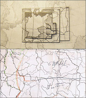
To navigate the dangers that lay ahead in this and other battles, intelligence relied on specialized ‘bigot’ maps — bigot standing for the maps’ secret classification.
Gathering the information for these critical maps was a responsibility of the Office of Strategic Services (OSS), America’s first centralized spy agency.
From a network of secret agents, informants and resistance fighters stationed in cities and villages across Europe — who often faced great risk, even death, if apprehended by the Nazis — the OSS amassed the data they needed.
Then, quietly, behind closed doors in Washington, D.C., a group of men and women from academia helped win the war simply by making sense of the data and putting it on maps that were easier to understand.
For years, the stories of these geographers and cartographers remained in the background, as most historians focused on the drama of OSS spies and informants on the front lines.
Now, Jeremy Crampton, an associate professor of geography, is using newly declassified archives from OSS vaults to help tell the stories of those whose maps helped soldiers navigate the battlefields and later helped policymakers draw up new boundaries for the post-war years.
He has co-authored a chapter of an upcoming book, ‘Reconstructing Conflict: Integrating War and Post-War Geographies,’ about the geographers’ and cartographers’ work.
‘The importance of the geographers’ role in planning can’t be underestimated,’ Crampton said. ‘Not many people have looked at this period in geography. And because there were so many people, not just geographers but academics working for this short, intense period in government, I think it says a lot about the relationship between academia and intelligence, and the policies of the war.’
Mapping the War
In the first days after the bombing of Pearl Harbor in December 1941, the U.S. had no single point for intelligence gathered by different parts of the government. The OSS would come to serve as that central point.
Led by William ‘Wild Bill’ Donovan, remembered as the ‘Father of American Intelligence,’ the OSS was composed of agents who braved the front lines to collect and pass along information, as well as scholars who could compile and interpret what they were gathering.
Donovan recruited some of the best and brightest from America’s universities to create a Research and Analysis (R&A) branch of the OSS.
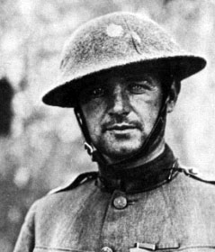
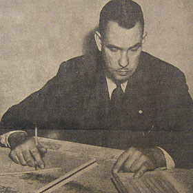
Within the branch, a mapping division of around 150 cartographers was created and led by a young professor from Ohio State University, 26-year-old Arthur H. Robinson.
Robinson’s team found themselves in new, unfamiliar territory.
As Robinson wrote in an article in the Annals of the Association of American Geographers in 1979, the geographers and analysts flew by the seat of their pants in the division’s early days.
‘The present student of cartography who has a high level of understanding would find it difficult to appreciate our ignorance,’ Robinson wrote about his early experiences.
Despite the initial learning curve, Robinson and his team were able to create accurate maps to help soldiers in the field familiarize themselves with the lay of the land and avoid hazards, Crampton said.
‘In one case, analysts working in the map division analyzed the defenses around the economically vital French city of Marseille, down to which specific location an ammunition dump was likely to be found,’ Crampton said.
Crampton said the OSS map division cartographers were very skilled in getting only what was needed on the maps.
‘This involved winnowing out the irrelevant details,’ he said. ‘In order to do this, you need to know for what purpose the map is going to be used. This implied that the United States’ policy and strategy was clearly articulate, which of course it sometimes was, and sometimes wasn’t.’
Charting the Post-War Period
Allied leaders were torn about how to shape the world after the war. Geographers within the R&A branch had provided President Franklin D. Roosevelt and Prime Minister Winston Churchill, and later President Harry Truman, with ‘president’s globes’ to use in their decision making. Robinson would attend meetings when the leaders discussed possible post-war plans.
Numerous proposals were made, but the biggest controversy revolved around what to do with Germany, Crampton said.
Henry Morgenthau, the U.S. Secretary of the Treasury, proposed an almost complete deindustrialization of Germany to, in the words of the New York Times, turn the nation into ‘a country of small farms.’

‘Not only was Morgenthau offended by the concentration camps, but he also seemed to genuinely believe that this was the best policy preventing Germany from being a military threat again,’ Crampton said. ‘A rural Germany would be a defanged Germany.’
Members of the OSS R&A branch were privately appalled by the plan, however, and the Morgenthau plan would later be scuttled in favor of reconstruction. Ultimately, the post-war partition of Germany came down to four zones of occupation — one by the U.S., one by France, one by the United Kingdom and one by the Soviet Union, with the city of Berlin carved into four pieces.
While maps produced by the OSS R&A branch were needed to show the population and resources of the defeated countries, interestingly enough, the exact demarcations weren’t of immediate importance to wartime leaders like Roosevelt.
‘I don’t think that Roosevelt was ultimately all that bothered by [the exact locations of the borders],’ Crampton said. ‘Looking at the maps, there was one where Roosevelt sat at lunch time and had a map. He had three colored pencils, drew where partitions would go, and someone came in and recorded it.’
The Politics of Maps
While studying documents at the National Archives and Records Administration this past summer, Crampton discovered that maps are very much influenced by the political climate surrounding them.
‘For example, in the case of Arthur Robinson, many years later in the 1970s, he became adamantly opposed to a new map that had been developed by a German historian, Arno Peters,’ Crampton said. ‘Robinson believed that the [Peters’ world map] was overtly political, and that it therefore distorted what cartography should be.
‘In his mind, cartography should strive for a purely objective representation of the landscape,’ Crampton explained.
Robinson’s experience in the OSS is a commentary on the role of mapping, Crampton said, especially when it comes to the politics behind the field.
‘If his maps were ‘wrong,’ then potentially lives would be at stake,’ he added. ‘This worldview, I suggest, has come to dominate cartography and geographic information systems in the post-war period.
‘I’d argue that, in fact, all maps are political in some way, and to ignore this is to ignore the basic power of maps,’ he said. ‘It’s ironic that it was this wartime government experience that has led cartography away from an engagement with its own politics.’
In any case, the maps of World War II are still with us today in the NARA archives, a testament to those who tried to make sense of the landscape in the heat and politics of perhaps one of the most critical, world-shaping wars in history.
Arthur H. Robinson’s Legacy
The man who headed up cartography for the Office of Strategic Services would go on to, literally, change our view of the world.
Arthur H. Robinson is often considered a key player in the creation of modern cartography. After World War II, he went on to join the faculty of the University of Wisconsin-Madison. His textbook, “Elements of Cartography,” has become the standard for educating young geographers.
One of Robinson’s key contributions addressed the challenge of accurately portraying the spherical Earth on a flat sheet of paper, so-named the “Greenland Problem” because on the then-popular Mercator map, the island appears to be about the size of South America, even though it’s only as large as Mexico.
Robinson was never satisfied with this. In 1963, he created his own map to more accurately reflect the Earth’s landforms. This map would be adopted by the National Geographic Society and is also the basis for maps in the federal government and several world atlases.
Even in the ’70s, Robinson foresaw modern techniques such as geographic information systems computer programs that help planners and governments make sense of the world today.
Maps courtesy of National Archives and Records Administration; Morgenthau inset courtesy of the Library of Congress